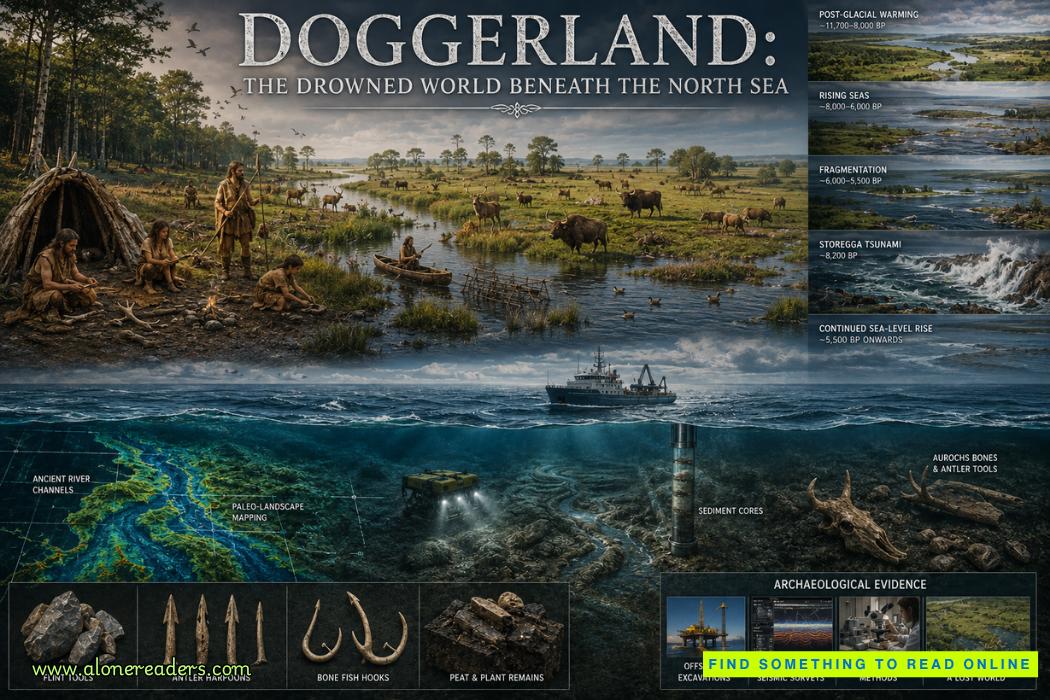
Doggerland sounds like the name of a legendary country, yet it was a real landscape inhabited by humans for thousands of years. Where fishing vessels, ferries, offshore platforms, and wind turbines now operate across the North Sea, there were once rivers, lakes, marshes, forests, open plains, animals, and communities of Stone Age hunter-gatherers. Britain was not yet an island separated from continental Europe. Instead, large areas of what is now seabed formed an extensive terrestrial world linking eastern Britain with regions that are today the Netherlands, Germany, Denmark, and surrounding parts of northwestern Europe.
Doggerland was not destroyed in a single dramatic night. Its disappearance was primarily the result of a vast environmental transformation following the last Ice Age. Melting ice sheets raised global sea levels, shorelines migrated inland, river valleys became estuaries, wetlands expanded, and increasingly large portions of the landscape disappeared beneath the sea. A major tsunami generated by the Storegga submarine landslide later struck parts of the remaining coastal landscape, adding a spectacular episode to a process of inundation that had already been underway for millennia.
The importance of Doggerland goes far beyond the fascination of a “lost land.” It changes how archaeologists understand prehistoric migration, settlement, subsistence, climate adaptation, and the relationship between Britain and continental Europe. The North Sea was once not a barrier between societies. Much of it was the landscape through which those societies moved.
At the height of the last glacial period, enormous quantities of Earth's water were locked inside continental ice sheets and glaciers. Global sea level was therefore dramatically lower than it is today. Large portions of the modern continental shelf were exposed as dry land, including extensive areas of the present North Sea basin.
The landscape did not remain constant. As temperatures increased after the coldest phase of the last Ice Age, vegetation, animals, rivers, coastlines, and human settlement patterns changed repeatedly. What archaeologists call Doggerland therefore existed in many different environmental forms rather than as one unchanging territory.
At various stages, the region contained river systems, shallow lakes, marshes, wooded zones, open grasslands, dunes, estuaries, and low hills. Some areas would have offered particularly attractive environments for hunter-gatherers because different ecological zones occurred close together. A community positioned near a river, wetland, woodland edge, and open ground could potentially exploit fish, waterfowl, mammals, edible plants, nuts, roots, wood, reeds, and stone resources within a relatively limited territory.
One of Doggerland's most important geographical features survives in its name: Dogger Bank. Today it is a broad, shallow area of the North Sea. During periods of lower sea level, however, portions of this elevated terrain formed part of the terrestrial landscape and later may have persisted as higher ground while surrounding lowlands were being flooded.
The name “Doggerland” can create the misleading impression that archaeologists have discovered a neatly bounded prehistoric country. No such political territory is implied. The term is a modern geographical and archaeological label for submerged landscapes that once occupied large portions of the North Sea basin.
Humans living there would not have thought of themselves as inhabitants of “Doggerland.” They lived within particular river valleys, hunting territories, seasonal camps, shorelines, wetlands, and social landscapes whose original names are permanently lost.
For Mesolithic communities, this environment could have been exceptionally productive. The old stereotype of hunter-gatherers wandering randomly across barren wilderness is particularly inappropriate here. Mesolithic subsistence could involve sophisticated knowledge of seasonal animal movements, fish runs, plant availability, waterways, woodland resources, and recurring gathering locations.
People could hunt red deer, roe deer, wild boar, aurochs, and other mammals, while wetlands and rivers offered fish, birds, aquatic resources, reeds, and freshwater. Hazel and other woodland plants provided important food and raw materials. Rivers were not merely obstacles. They functioned as ecological corridors, sources of food, landmarks, and potentially routes of transportation.
Dugout canoes and other watercraft known from Mesolithic Europe demonstrate that prehistoric communities were capable of navigating rivers, lakes, estuaries, and coastal waters. As Doggerland became progressively wetter and more fragmented, such skills would have become increasingly important.
Settlement was probably dynamic. Instead of permanent villages resembling later farming communities, many groups may have moved between repeatedly used locations according to season, resource availability, social relationships, and environmental conditions. Certain riverbanks, lake margins, woodland clearings, and coastal zones could have been revisited across generations.
This makes the archaeological loss particularly frustrating. Some of the most desirable prehistoric settlement areas are precisely those now buried beneath marine sediments.
The drowning of Doggerland was ultimately connected to one of the greatest climatic transitions in recent geological history: the end of the last Ice Age.
As the planet warmed, enormous ice sheets covering northern Europe and North America began losing mass. Water returned to the oceans, and global sea level rose substantially. The effect on low-lying continental shelves was transformative.
Sea-level rise should not be imagined as water advancing across a perfectly flat surface at a uniform speed. Real landscapes contain valleys, ridges, drainage basins, depressions, river channels, and differences in elevation. Consequently, inundation created complex and continually changing coastlines.
A river valley might first experience increased tidal influence. Farther downstream, freshwater wetlands could become brackish. Estuaries could expand inland. Low depressions might flood while nearby ridges remained dry. Former inland areas could become peninsulas, and peninsulas could eventually become islands.
For the people experiencing these changes, the transformation unfolded over generations.
A campsite remembered by grandparents might become increasingly marshy. A traditional hunting route could be interrupted by a new tidal channel. Familiar freshwater resources might become saline. Communities could relocate toward higher ground while still returning seasonally to productive wetlands.
This slow human dimension is one of the most compelling aspects of Doggerland. Its inhabitants were living through environmental change that was gradual on the scale of geology but potentially dramatic on the scale of generations.
Britain's transformation into an island was also a process rather than a single event. As sea levels rose and marine waters penetrated previously terrestrial areas, connections between Britain and continental Europe narrowed and eventually disappeared.
This geographical separation had profound consequences. The movement of humans, animals, plants, technologies, and cultural traditions increasingly required water crossings rather than simple movement across continuous land.
Yet the creation of the English Channel and North Sea coastlines did not suddenly isolate Britain culturally. Prehistoric communities possessed maritime capabilities, and contacts across water continued. Geography altered the conditions of movement without eliminating movement itself.
Among the most dramatic events associated with Doggerland was the Storegga submarine landslide, which occurred off the Norwegian coast roughly eight thousand years ago.
An enormous volume of sediment collapsed underwater along the continental margin. This displacement generated a tsunami that propagated across the Norwegian Sea and into surrounding coastal regions. Geological deposits provide evidence that large waves reached parts of Scotland and other North Atlantic and North Sea shorelines.
Doggerland lay directly within the broader region affected.
The possibility of Mesolithic communities witnessing enormous waves racing across low-lying coastal terrain is extraordinary. Camps could have been destroyed, people killed, freshwater systems contaminated, vegetation damaged, and coastlines reorganized.
For years, popular descriptions sometimes portrayed the Storegga tsunami as the catastrophe that suddenly destroyed Doggerland. Modern interpretation requires greater caution.
Doggerland was already shrinking because of long-term sea-level rise before the tsunami occurred. The Storegga event may have devastated surviving coastal communities and landscapes, but it should not automatically be treated as the single event responsible for submerging the entire region.
Some higher areas may have survived after the tsunami. Depending on sea level, local topography, and chronology, remnants of the former landscape could have persisted temporarily as islands or coastal zones before later inundation completed their transformation.
The distinction matters because Doggerland represents both gradual environmental change and episodic catastrophe. Reducing its story to one giant wave obscures the much longer process through which generations adapted to disappearing territory.
For centuries, people working in the North Sea encountered clues that something unusual existed beneath the water. Fishermen occasionally hauled up bones, antlers, peat, and prehistoric artifacts from areas far offshore.
Such discoveries were difficult to interpret when considered individually. A bone recovered in a fishing net might have been displaced from its original geological context. A stone artifact found on the seabed provided evidence of human presence but revealed little about the surrounding landscape.
The transformation came when researchers began treating the North Sea floor as a buried prehistoric landscape rather than merely an archaeological collection point.
Modern offshore industries have played an unexpected role in this process. Oil, gas, infrastructure, dredging, and wind-energy projects have generated enormous quantities of geological and geophysical information about the seabed. Data originally collected for engineering or resource exploration can help researchers identify ancient channels, valleys, sedimentary basins, and former land surfaces.
High-resolution seismic surveying is particularly valuable. Sound waves sent through sediments produce reflections from buried geological boundaries. When processed and interpreted, these data can reveal structures invisible beneath the modern seafloor.
Researchers can effectively reconstruct parts of an ancient topography.
They have identified palaeochannels, former river systems, depressions, ridges, wetlands, and other landscape features. Instead of imagining Doggerland as an abstract block of land on a lowered-sea-level map, archaeologists can increasingly investigate it as a structured environment containing specific places where humans may have lived.
Sediment cores provide another critical source of evidence. Layers preserved beneath the seabed can contain pollen, plant remains, microscopic organisms, organic material, and chemical signatures that reveal past environmental conditions.
Pollen can indicate changes in vegetation. Peat may demonstrate the former existence of marshes or terrestrial wetlands. Marine sediments deposited above terrestrial layers can document the transition from land to tidal or fully marine conditions.
Animal remains reveal another dimension of the vanished ecosystem. Mammoth bones are among the most visually impressive finds from the North Sea, although mammoths belong primarily to earlier colder landscapes rather than the later Mesolithic world most strongly associated with Doggerland. Other remains testify to changing faunas as climate warmed and environments shifted.
Human-made objects are even more important. Flint tools, worked bone, and antler artifacts demonstrate that the submerged territory was not merely habitable land—it was inhabited and exploited by people.
One particularly intriguing category involves objects recovered from material dredged from the North Sea. Such finds can include prehistoric tools and animal remains deposited when these areas were dry land or freshwater environments.
The central archaeological challenge is context. An isolated artifact tells researchers that humans were somewhere in the region. An artifact found within an intact sedimentary layer associated with a former riverbank, hearth, structure, or occupation surface could reveal vastly more.
This is why finding preserved archaeological sites beneath the North Sea is one of the major goals of Doggerland research.
Submerged preservation can sometimes be surprisingly good. Waterlogged sediments may protect organic materials that normally decay on dry archaeological sites. Wood, plant fibers, bone, antler, and other fragile materials could theoretically survive under favorable conditions.
At the same time, the North Sea is an extremely difficult archaeological environment. Currents, erosion, sediment movement, dredging, construction, fishing activity, and marine processes can disturb deposits. Archaeologists cannot excavate thousands of square kilometers of seabed using conventional terrestrial techniques.
Instead, Doggerland research increasingly depends on a combination of marine geophysics, environmental archaeology, geological modelling, targeted coring, radiocarbon dating, artifact analysis, and ancient biomolecular techniques.
Environmental DNA offers especially exciting possibilities. Organisms leave genetic traces in sediments, and under suitable preservation conditions researchers can potentially identify plants and animals even when visible bones or plant remains are absent.
The result is a fundamentally interdisciplinary form of archaeology. Reconstructing Doggerland requires archaeologists to work alongside geologists, palaeoecologists, geophysicists, marine scientists, climate researchers, and offshore engineers.
Doggerland is therefore not simply a lost archaeological site. It is an entire submerged research landscape.
Its significance also extends into the study of prehistoric migration. Traditional maps of European prehistory can unconsciously impose modern coastlines on ancient populations. This creates a distorted picture.
When Mesolithic humans moved between what are now Britain, Belgium, the Netherlands, Germany, and Denmark, they were operating within a geography radically different from ours. Some journeys that appear maritime on modern maps may once have been overland. Areas now considered peripheral coastal zones could have been connected through major river systems extending across the exposed shelf.
The North Sea basin may therefore have been central rather than marginal to the human geography of northwestern Europe.
This realization forces archaeologists to reconsider population distribution. A large amount of prehistoric territory is simply missing from conventional archaeological maps because it lies underwater. The apparent concentration of sites along today's coastlines may partly reflect preservation and accessibility rather than the true distribution of prehistoric populations.
Doggerland also provides a powerful case study in human adaptation to climate change, although comparisons with the modern world must be made carefully.
Mesolithic populations were much smaller, possessed different technologies, had different political systems, and did not depend on modern cities, ports, electrical grids, industrial agriculture, or national borders. Their circumstances cannot simply be transferred to modern climate projections.
Nevertheless, their experience demonstrates something fundamental: coastlines are temporary geographical arrangements.
Human societies often treat coastlines as permanent boundaries. Geological history shows otherwise. Sea level changes, sediments move, deltas migrate, storms reshape shores, and land can rise or sink.
For Doggerland's inhabitants, environmental change transformed geography itself. Hunting territories disappeared. Rivers became estuaries. Freshwater environments turned saline. Communities moved. Social networks had to accommodate shrinking land and changing routes.
Eventually, entire landscapes survived only as memory.
Today even those memories are gone. No oral tradition can reliably take us back eight thousand years to the people who watched their world disappear beneath the North Sea. Their languages, personal names, myths, territorial identities, and explanations for the rising waters are unknown.
Yet the physical traces of their world remain.
They survive in submerged river channels beneath marine sediment, pollen trapped in ancient deposits, peat formed in vanished wetlands, animal bones lifted from fishing grounds, stone tools recovered from dredged material, and increasingly sophisticated maps created from geophysical data.
Doggerland is therefore one of archaeology's most remarkable inversions. The sea itself has become an archaeological landscape.
What appears on a modern map as empty blue water was once filled with places meaningful to human beings: hunting grounds, pathways, campsites, river crossings, fishing locations, woodland edges, gathering areas, and perhaps locations carrying stories that had been passed between generations.
Its disappearance also reminds us that archaeological history is biased toward surviving land. Vast portions of humanity's prehistoric experience occurred on continental shelves exposed during periods of lower sea level. As oceans rose after the Ice Age, many of those landscapes vanished underwater around the world.
Doggerland is simply one of the most extensively studied examples.
Future discoveries may transform the picture again. Offshore wind development and increasingly detailed seabed surveys are generating unprecedented information about North Sea geology. Improved dating methods, sediment analysis, ancient DNA research, underwater robotics, and high-resolution mapping may eventually allow archaeologists to locate preserved occupation surfaces or settlements with far greater precision.
The ultimate prize would not merely be another isolated stone tool. It would be a well-preserved archaeological context showing exactly how people organized their lives within the disappearing landscape.
Until then, Doggerland remains simultaneously known and elusive. Scientists can map ancient valleys, reconstruct vegetation, identify episodes of flooding, recover artifacts, and model changing coastlines. But the human stories contained within that geography are only beginning to emerge.
Beneath the waves between Britain and continental Europe lies the remains of a world that once seemed as ordinary and permanent to its inhabitants as our own landscapes appear to us today. Rivers flowed through valleys that no longer exist. Animals moved through forests now covered by seawater. Families returned to familiar places that eventually vanished.
Doggerland was not a mythical Atlantis. It was something scientifically more extraordinary: a real inhabited landscape erased from the map by the transformation of the post-Ice Age Earth.

 Château de Carcassonne: Europe’s Greatest Medieval Citadel and Fortress
 Château de Chenonceau: The Castle Built by Remarkable Women
 Château de Chambord: France’s Magnificent Renaissance Castle and Architectural Wonder
 Tehri Dam: India's Tallest Dam and the Debate Behind It
 Bhakra Nangal Dam: India's Temple of Modern Development
 Mangla Dam: Pakistan's Second Great Water Project