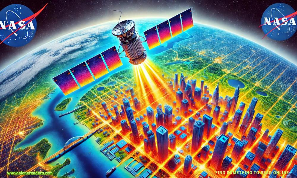
Urban heat is a growing concern in the context of climate change, and NASA’s ECOSTRESS mission is at the forefront of efforts to understand and mitigate its effects. The ECOsystem Spaceborne Thermal Radiometer Experiment on Space Station (ECOSTRESS) is a revolutionary mission designed to monitor temperature changes from the vantage point of the International Space Station (ISS). This mission plays a crucial role in understanding how different parts of the Earth's surface respond to changes in temperature, particularly in urban areas, which are notorious for their heat-retaining properties.
The primary objective of the ECOSTRESS mission is to measure the temperature of the Earth's surface with unprecedented accuracy. This is achieved through the use of a sophisticated thermal infrared radiometer, which can detect temperature differences as small as a few tenths of a degree. By capturing high-resolution temperature data, ECOSTRESS provides detailed insights into the thermal properties of various landscapes, including urban environments.
Urban areas, often referred to as "heat islands," tend to be significantly warmer than their rural counterparts due to human activities and the prevalence of heat-absorbing materials like concrete and asphalt. These heat islands can have a profound impact on local climates, exacerbating heatwaves and increasing energy demands for cooling. By monitoring these urban heat islands, ECOSTRESS helps scientists and policymakers develop strategies to mitigate their effects.
One of the key advantages of ECOSTRESS is its ability to capture temperature data at different times of the day. Unlike many other Earth observation instruments, which are typically limited to a single time of day, ECOSTRESS can observe the same location multiple times within a 24-hour period. This capability allows scientists to study the diurnal variations in temperature, providing a more comprehensive understanding of how urban areas heat up and cool down over the course of a day.
The data collected by ECOSTRESS is invaluable for a variety of applications. For instance, urban planners can use this information to design cities that are more resilient to heatwaves. By identifying hotspots within a city, planners can implement targeted interventions, such as increasing green spaces or using reflective materials to reduce heat absorption. Additionally, the data can inform public health strategies by identifying areas that are most vulnerable to extreme heat, allowing for better resource allocation and emergency response planning.
ECOSTRESS also plays a critical role in advancing scientific research on climate change. By providing detailed temperature data over time, the mission helps researchers understand how urbanization and land-use changes contribute to global warming. This information is essential for developing accurate climate models, which are used to predict future climate scenarios and guide policy decisions.
One of the most significant achievements of the ECOSTRESS mission is its contribution to understanding the relationship between water and temperature stress in plants. By measuring the temperature of plant leaves, ECOSTRESS can infer the amount of water being used by plants for transpiration. This is crucial for managing water resources, especially in regions that are prone to drought. By understanding how plants respond to temperature and water availability, scientists can develop better irrigation practices and improve agricultural productivity.
Moreover, ECOSTRESS has the potential to enhance our understanding of the urban heat island effect on a global scale. By comparing temperature data from different cities around the world, scientists can identify common factors that contribute to urban heating. This knowledge can inform global efforts to combat climate change by promoting sustainable urban development practices that minimize heat retention and reduce greenhouse gas emissions.
The success of the ECOSTRESS mission is a testament to the power of satellite technology in addressing some of the most pressing environmental challenges of our time. By providing high-resolution temperature data, ECOSTRESS enables a deeper understanding of the complex interactions between urbanization, land use, and climate change. This information is critical for developing effective strategies to mitigate the impacts of urban heat islands and build more sustainable and resilient cities.
In conclusion, NASA’s ECOSTRESS mission is a groundbreaking initiative that leverages advanced satellite technology to monitor urban heat and its effects. By capturing detailed temperature data, ECOSTRESS provides valuable insights that inform urban planning, public health, and climate research. As cities continue to grow and the impacts of climate change become more pronounced, the importance of missions like ECOSTRESS cannot be overstated. They offer a window into the future, helping us understand how our actions today will shape the climate of tomorrow.

December 27, 2022

January 11, 2023

December 20, 2022

January 19, 2023
 Golan Heights Tensions: Hezbollah Launches Rocket Attacks on Israeli Positions
 Syrian Refugee Crisis Deepens: Thousands Flee as Conflict Intensifies
 Ukraine’s Counteroffensive in Donbas: Intensified Efforts to Reclaim Territory
 El Niño’s Global Impact: Meteorologists Warn of Record Temperatures and Extreme Weather
 French President Macron Unveils New Immigration Policies in Major Address
 EU Parliament Criticizes Hungary's EU Council Presidency Bid Amid Democratic Concerns
 Hungarian Relations with the EU Strained Amid Upcoming Council Presidency
 Hurricane Emily Approaches U.S. East Coast: Potential for Significant Damage Looms
 International Orangutan Day: Global Efforts to Protect Endangered Orangutans
 Hereford River Carnival 2024: A Vibrant Celebration of Community Spirit, Music, and Food
 A Compelling Journey of Love and Trust in "The Demetrios Virgin" by Penny Jordan
 Seduced into the Greek's World by Dani Collins: A Compelling Journey of Passion and Power
 A Passionate Desert Romance: Review of Captured by the Sheikh by Kate Hewitt
 A Passionate Reunion: The Cozakis Bride by Lynne Graham - Book Review
 African Blackwood: The World’s Most Expensive and Rare Timber
 Hug Me Coca-Cola Machine in Singapore: A Free Coke for Every Hug